
3-Axis Gimbal Camera

The Mavic Air is the most portable DJI drone to house a 3-axis mechanical gimbal, with its angular vibration range reduced to 0.005°. Set in a triangular formation, gimbal dampeners help create even steadier shots.32 MP Sphere Panoramas

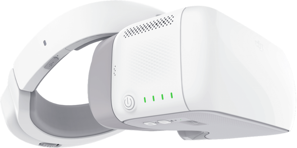
In addition to Horizontal, Vertical, and 180° panoramas, the Mavic Air stitches 25 photos together in just eight seconds to create crystal-clear 32 MP Sphere panoramas.1 View them from an immersive perspective with DJI Goggles.4K 100 Mbps Video

The Mavic Air shoots video at an incredible 4K 30 fps, recording at 100 Mbps to capture every second with UHD quality.Slow-Motion Video

With support for recording 1080p 120 fps slow-motion video, the Mavic Air captures all your epic high-speed adventures.HDR Photos

New HDR algorithms help you obtain the right exposure settings intelligently, according to lighting conditions. Overexposed or dark areas are processed for more natural transitions between highlights and shadows, while DSP acceleration allows for more efficient shooting.12 MP StillsThe Mavic Air’s onboard camera integrates a 1/2.3” 12-megapixel CMOS sensor and an f/2.8 lens with a 35-mm equivalent focal length of 24 mm to shoot high-quality photos and videos.8 GB Internal Storage

In addition to a Micro SD card slot, 8 GB of internal storage let you save photos and videos directly to the aircraft and export files through its USB 3.0 Type-C port.Geometric Elegance

Expressing geometric precision, the Mavic Air’s arms fold flush against its aerodynamic chassis. Magnesium alloy brackets reinforce the seven onboard cameras, rear vents dissipate heat efficiently, and the primary gimbal camera is recessed for better protection.3D Foldable Design

As tall and wide as a smartphone when folded, the Mavic Air is an ultraportable drone that stretches the boundaries of what’s possible for a device its size.Foldable Remote Controller

The dedicated remote controller uses a foldable, low-profile, ergonomic design to hold your smartphone for maximum convenience. Detachable control sticks store inside the remote controller to pack more comfortably on the go.

ActiveTrack

ActiveTrack can sense up to 16 selectable subjects simultaneously,2 letting you choose the right tracking subject. With higher tracking precision and broader scenario applications, ActiveTrack follows targets even when they’re running, jumping, or cycling.QuickShots

Choose from six different QuickShots — Rocket, Dronie, Circle, Helix, Asteroid, and Boomerang. All are just a tap away and will get you those epic selfie drone videos without needing to think about composing your shot. Share your new creations to social media through the DJI GO 4 app instantly.SmartCapture

Fun, simple, and intuitive, SmartCapture offers a new and interactive way of controlling the Mavic Air by hand. Launch and control the drone with hand gestures, then take photos or videos however you like.TapFly

If you want to focus on just your shot, select TapFly in DJI GO 4, which lets you fly wherever you tap on your mobile device screen. TapFly works in Forward, Backward, Free, and Coordinate modes, and you can adjust flight speed to suit all your aerial needs.

FlightAutonomy 2.0

Using advanced VIO technology, the powerful sensor system in FlightAutonomy 2.0 consists of a primary gimbal camera, forward, backward, and downward dual-vision sensors, downward infrared sensing system, IMU redundancies, and a group of computing cores. Together, they collect and transmit information from the surrounding environment to the high-performance processor for more precise hovering and better flight performance. Advanced Pilot Assistance Systems (APAS) allow the aircraft to bypass obstacles in front of and behind it actively. Your grand adventures of discovery have never been so safe and easy.Visual Inertial Odometry (VIO)

A combination of VIO technology and the new positioning algorithm has doubled the Mavic Air’s precision positioning. VIO technology calculates the speed and attitude of the aircraft in real-time and locates it, making dual-camera attitude measurements while hovering or flying at any speed. The working range of the vision positioning system is now 0.5 to 30 meters. With VIO technology, the Mavic Air hovers more precisely indoors and responds better to complex environments with finer control stick movement.3D Map Building

Equipped with an advanced sensing system, the Mavic Air locates itself with accuracy and precision. By processing data from the seven cameras at the front, bottom, and rear of the body, alongside the advanced infrared sensors and IMU, the Mavic Air will construct a 3D map by sensing the environment in real time, which significantly improves overall flight safety.Advanced Pilot Assistance Systems (APAS)

APAS is the result of DJI’s extensive research on flight path calculation. Users can keep flying forwards and backwards, and APAS will plan an appropriate flight path to bypass obstacles automatically.Multiple Redundancies

Besides dual IMUs, FlightAutonomy 2.0 has more redundant modules to increase the Mavic Air’s safety level. The Vision Compass will assist the navigation system to estimate flight direction when the compass experiences interference. When only one direction of the front, bottom, or rear vision systems is functioning normally, the aircraft will still position itself successfully. There are two sets of sensor fusion algorithms based on two independent hardware platforms. When an error occurs to one set of algorithms, the aircraft will switch to the other pair seamlessly to resume normal functionality.More Reliable Return to Home (RTH)

Expanding on existing RTH systems, the Mavic Air will ensure the safest flight path during RTH. It does this by recording its real-time flight path, and when the control signal gets lost, the aircraft will fly towards the Home Point, bypassing any signal obstruction and reconnect to the controller. When the Mavic Air detects an obstacle, it will choose a proper path to bypass it according to its altitude. The aircraft will match the images of the ground with those captured at takeoff for increased landing accuracy. When landing automatically, the Mavic Air will scan the terrain of the landing area in real-time, then warn the user and safely hover if it detects an obstacle or water in the landing area.Flight Performance The Thrill of Flight21- Max Flight Time: 21 min

Mavic Air Intelligent Flight Batteries are made with high-density lithium, offering a substantial flight time of up to 21 minutes for all your adventuring needs.FOC ESCs and Propulsion

The application of FOC sinusoidal drive architecture ESCs provides the Mavic Air with a smoother motor commutation process and higher overall efficiency of both motors and ESCs.Max Speed:68.4 kph

Feel the rush and thrill of first-class drone flight with top speeds of 68.4 kph in Sport mode.Enhanced Wi-Fi Video Transmission

A new Wi-Fi video transmission system supports dual frequency bands of 2.4/5.8GHz and a 720p live view from up to 4 km away.DJI Goggles

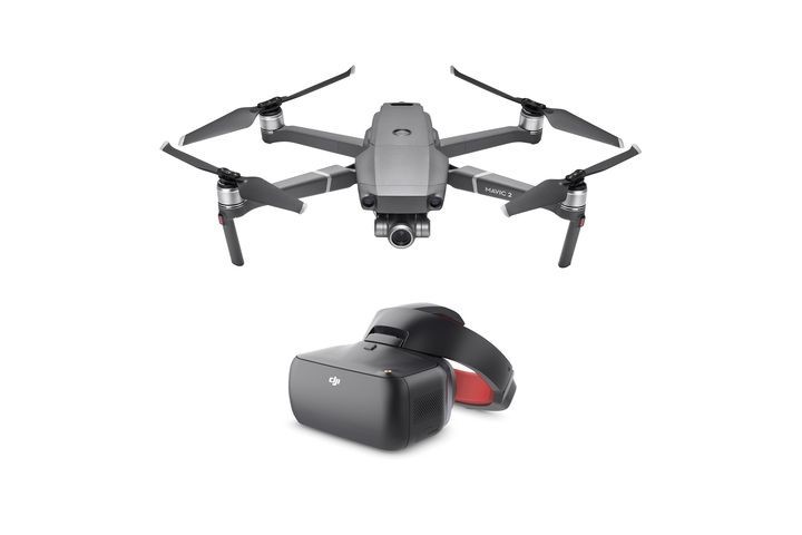
Pair the Mavic Air with the DJI Goggles for FPV flight, and take to the skies for an immersive aerial adventure.
Specifications
| Max Ascent Speed | 4 m/s (S – mode[1]) 2 m/s (P – mode) 2 m/s (Wi-Fi mode) |
| Max Descent Speed | 3 m/s (S – mode[1]) 1.5 m/s (P – mode) 1 m/s (Wi-Fi mode) |
| Max Speed (near sea level, no wind) | 68.4 kph (S – mode[1]) 28.8 kph (P – mode) 28.8 kph (Wi-Fi mode) |
| Max Service Ceiling Above Sea Level | 5000 m |
| Max Flight Time (no wind) | 21 minutes (at a consistent 25 kph) |
| Max Hovering Time (no wind) | 20 minutes |
| Max Flight Distance (no wind) | 10 km |
| Max Wind Speed Resistance | 29 – 38 kph |
| Max Tilt Angle | 35° (S – mode[1]) 15° (P – mode) |
| Max Angular Velocity | 250°/s (S – mode[1]) 250°/s (P – mode) |
| Operating Temperature Range | 0°C – 40°C |
| Operating Frequency | 2.400 – 2.4835 GHz 5.725 – 5.850 GHz |
| Transmission Power (EIRP) | 2.400 – 2.4835 GHz FCC: ≤28 dBm CE: ≤19 dBm SRRC: ≤19 dBm MIC: ≤19 dBm 5.725 – 5.850 GHz FCC: ≤31 dBm CE: ≤14 dBm SRRC: ≤27 dBm |
| GNSS | GPS + GLONASS |
| Hovering Accuracy Range | Vertical: ±0.1 m (with Vision Positioning) ±0.5 m (with GPS Positioning) Horizontal: ±0.1 m (with Vision Positioning) ±1.5 m (with GPS Positioning) |
| Internal Storage | 8 GB |
| Forward | Precision Measurement Range: 0.5 – 12 m Detectable Range: 0.5 – 24 m Effective Sensing Speed: ≤ 8 m/s Field of View (FOV): Horizontal 50°, Vertical ±19° |
| Backward | Precision Measurement Range: 0.5 – 10 m Detectable Range: 0.5 – 20 m Effective Sensing Speed: ≤ 8 m/s Field of View (FOV): Horizontal 50°, Vertical ±19° |
| Downward | Altitude Range: 0.1 – 8 m Operating Range: 0.5 – 30 m |
| Operating Environment | Forward: Surface with clear pattern and adequate lighting (lux > 15) Backward: Surface with clear pattern and adequate lighting (lux > 15) Downward: Detects clearly patterned surfaces with adequate lighting (lux>15) and diffuse reflectivity (>20%) |
| Operating Frequency | 2.400 – 2.4835 GHz 5.725 – 5.850 GHz |
| Max Transmission Distance (unobstructed, free of interference) | 2.400 – 2.4835 GHz: FCC: 4000 m CE: 2000 m SRRC: 2000 m MIC: 2000 m 5.725 – 5.850 GHz: FCC: 4000 m CE: 500 m SRRC: 2500 m |
| Operating Temperature Range | 0℃ – 40℃ |
| Transmission Power (EIRP) | 2.400 – 2.4835 GHz: FCC : ≤26 dBm CE: ≤18 dBm SRRC: ≤18 dBm MIC:≤18 dBm 5.725 – 5.850 GHz: FCC: ≤30 dBm CE: ≤14 dBm SRRC: ≤26 dBm |
| Battery | 2970 mAh |
| Operating Current/Voltage | 1400 mA = 3.7 V (Android) 750 mA = 3.7 V (iOS) |
| Supported Mobile Device Size | Max length: 160 mm Supported Thickness: 6.5-8.5 mm |
| Supported USB Port Types | Lightning, Micro USB (Type-B), USB-C |
| Input | 100 – 240 V, 50/60 Hz, 1.4 A |
| Output Main: | 13.2 V = 3.79 A |
| USB: | 5 V = 2 A |
| Voltage | 13.2 V |
| Rated Power | 50 W |
| Video Transmission System | Enhanced Wi-Fi |
| Name | DJI GO 4 |
| Live View Quality | Remote Controller: 720p@30fps Smart Device: 720p@30fps DJI Goggles: 720p@30fps |
| Latency (depending on environmental conditions and mobile device) | 170 – 240 ms |
| Required Operating System | iOS v9.0 or later Android v4.4 or later |
| Footnotes | [1] Remote controller reqired. |
| Mechanical Range | Tilt: -100° to 22° |
| Roll: | -30° to 30° |
| Pan: | -12° to 12° |
| Controllable Range Tilt: | -90° to 0° (default setting) -90° to +17° (extended) |
| Stabilization | 3-axis (tilt, roll, pan) |
| Max Control Speed (tilt) | 120°/s |
| Angular Vibration Range | ±0.005° |
| Sensor | 1/2.3” CMOS Effective Pixels: 12 MP |
| Lens | FOV: 85° 35 mm Format Equivalent: 24 mm Aperture: f/2.8 Shooting Range: 0.5 m to ∞ |
| ISO Range | Video: 100 – 1600 (auto) 100 – 1600 (manual) Photo: 100 – 1600 (auto) 100 – 3200 (manual) |
| Shutter Speed | Electronic Shutter: 8 – 1/8000s |
| Still Image Size | 4:3: 4056×3040 16:9: 4056×2280 |
| Still Photography Modes | Single shot HDR Burst shooting: 3/5/7 frames Auto Exposure Bracketing (AEB): 3/5 bracketed frames at 0.7EV Bias Interval: 2/3/5/7/10/15/20/30/60 s |
| Video Resolution | 4K Ultra HD: 3840×2160 24/25/30p 2.7K: 2720×1530 24/25/30/48/50/60p FHD: 1920×1080 24/25/30/48/50/60/120p HD: 1280×720 24/25/30/48/50/60/120p |
| Max Video Bitrate | 100Mbps |
| Supported File System | FAT32 |
| Photo Format | JPEG/DNG (RAW) |
| Video Format | MP4/MOV (H.264/MPEG-4 AVC) |
| Operating Frequency | 2.400 – 2.4835 GHz 5.725 – 5.850 GHz |
| Max Transmission Distance (unobstructed, free of interference) | Distance: 80 m Height: 50 m |
| Capacity | 2375 mAh |
| Voltage | 11.55 V |
| Max Charging Voltage | 13.2 V |
| Battery Type | LiPo 3S |
| Energy | 27.43 Wh |
| Net Weight | 140 g |
| Charging Temperature Range | 5℃ – 40℃ |
| Max Charging Power | 60 W |
| Supported SD Cards | microSD Class 10 or UHS-1 rating required |
| Recommended microSD Cards | 16G Sandisk Extreme Kingston 16GB SDHC-I SDCAC/16GB 32G Sandisk Extreme V30 Sandisk Extreme V30 A1 Sandisk Extreme V30 Pro A1 64G Sandisk Extreme V30 A1 Sandisk Extreme Pro V30 A1 128G Sandisk Extreme V30 A1 Sandisk Extreme Plus V30 A1 |
What’s in the Box
- Aircraft* x 1
- Remote Controller x 1
- Intelligent Flight Battery x 1
- Charger x 1
- Power Cablex 1
- Propellers (Pair)x 4
- Propeller Guards (Set)x 1
- RC Cable (Lightning connector)x 1
- RC Cable (Standard Micro USB connector)x 1
- RC cable (USB Type-C connector) x 1
- Gimbal Protector x 1
- Communication cable (USB3.0 Type-C)x 1
- USB Adapterx 1
- RC Cable Slider (Large) x 1
- RC Cable Slider (Small) x 2
- Carryleg Case x 1
- Spare Control Sacks (Pair)** x 1
[1] The sky above the camera cannot be captured due to the gimbal’s limited tilt range. Instead, the sky is automatically generated using a zenith patching algorithm.
[2] Acquired at a constant speed of 25 kph, free of wind. Actual flight time may vary because of the environment and use of flight modes.
[3] Including people, cars, and watercraft.
[4] Acquired near sea level, free of wind.
[5] Remote controller required. When in Sport mode, the aircraft cannot sense obstacles. Fly with caution.
[6] Due to local policies, some countries do not support 5.8 GHz transmission.
[7] Unobstructed, free of interference, when FCC compliant. The max transmission distance is 2 km when CE compliant.
FAQ
| Collapse group headingPRODUCT | |
|---|---|
| 1.How many ways are there to fly the Mavic Air and how do I change control methods? | There are three ways to fly the Mavic Air. You can use the dedicated remote controller, your smartphone, or both together. For the other two options, the Mavic Air connects to your smartphone via DJI GO 4. |
| 2.How do I activate the Mavic Air? | Connect the Mavic Air with your mobile device and follow the instructions in DJI GO 4 to complete activation. |
| 3.Is the Mavic Air waterproof? | No. |
| 4.What Micro SD cards are recommended to use with the Mavic Air? | SD Card Capacity Class/UHS 16 GB Sandisk Extreme; Kingston SDHC-I SDCAC/16GB 32 GB Sandisk Extreme V30; Sandisk Extreme V30 A1; Sandisk Extreme V30 Pro A1 64 GB Sandisk Extreme V30 A1; Sandisk Extreme Pro V30 A1 128 GB Sandisk Extreme V30 A1;Sandisk Extreme Plus V30 A1 |
| 5.Can I connect my phone and DJI Goggles simultaneously to the Mavic Air remote controller and still see a real-time video feed? | No. Although the two USB ports on the remote controller support video signal, they are unable to output video signal simultaneously. |
| Collapse group headingREMOTE CONTROLLER | |
| 1.Can I connect my smartphone to the remote controller using an ordinary USB cable? | Yes. You can use an ordinary USB cable to connect your smartphone to the remote controller via the USB port at the bottom of the controller, but this may result in more discomfort when handling. Different cables come with the aircraft to meet your needs. |
| 2.Where can I find the Mavic Air’s Wi-Fi name and password? | For safety reasons, every Mavic Air has a unique Wi-Fi name and password. These are listed on the side of the aircraft body, in the battery compartment, and on the carrying case. (For iOS systems, iOS v9.0 or later is required.) Connect your smartphone to the aircraft’s Wi-Fi by scanning the QR code with DJI GO 4 app for first-time use. Alternatively, you can manually type in the Wi-Fi name and password. |
| 3.How can I change the Mavic Air’s Wi-Fi name and password? | First, connect your smartphone to the aircraft via Wi-Fi. Next, enter the DJI GO 4 app and go to Wi-Fi Settings to change the Wi-Fi name and password. You can also change the Wi-Fi name and password with DJI Assistant 2 on a computer. |
| 4.Is it possible to connect to the Mavic Air’s Wi-Fi by using a third-party app to scan the QR code? | No. You can only scan the QR code to connect to the aircraft’s Wi-Fi using DJI GO 4. |
| Collapse group headingFEATURES | |
| 1.What is the maximum control range of the Mavic Air in SmartCapture? | The control range is 8.219.68 ft (26 m). |
| 2.What Panorama modes does the Mavic Air support? | The Mavic Air supports the following panorama modes: Vertical: The camera automatically takes three vertical photos, stitching them into one panorama. Horizontal: The camera will take nine photos from different angles, stitching them into one panorama. 180°: The Mavic Air automatically rotates its body and gimbal shooting 21 pictures, stitching them together in DJI GO 4 for a breathtaking 180° panorama. Sphere: The Mavic Air automatically rotates its body and gimbal to shoot 25 photos, stitching them together for an eye-catching spherical panorama. |
| 3.When flying the Mavic Air close to me in SmartCapture mode, why does the aircraft remain at eye level? | SmartCapture only allows the Mavic Air to fly at eye level when it’s 9.8 feet (3 meters) or less away from you. This is to ensure better flight safety and control precision. You can gesture to fly higher or lower when it’s farther away from you. |
| Collapse group headingBATTERIES | |
| 1.Can the Mavic Air Battery Charger be used to charge the aircraft and RC at the same time? | Yes. |
| 2.What is the Battery to Power Bank Adaptor used for? | Users can insert the adaptor into a battery and turn it into a mobile power bank. |
| 3.What functions does the power button perform? | The power button powers on and off the battery. To do this, press it once, and then press again, holding it for at least two seconds to power on or off the battery. The power button also allows you to check the battery level. To do this, press the power button once and observe how many LEDs light up for the power level. |
| 4.How long does it take to charge a battery fully? | It takes 55 minutes to charge a battery fully when using a standard charger or a Charging Hub. |
| 5.How often should I charge my batteries? | It is recommended to charge batteries at least once every three months fully. |
| Collapse group headingPROPULSION | |
| 1.What is the highest level of wind the Mavic Air can resist? | The Mavic Air can withstand wind speeds up to 10 m/s. |
| 2.What is the Mavic Air’s max service ceiling above sea level? | 16,400 ft (5000 m). |
| 3.Why does the Mavic Air use non-foldable propellers? | The non-foldable propellers are more streamlined, making the Mavic Air smaller and more portable when folded. |
| Collapse group headingUPDATING FIRMWARE | |
| 1.Can I use other apps while updating DJI GO 4? | No. If you do, the update will fail. You will then need to download the firmware and update again. |
| 2.Why does DJI GO 4 remind me to reconnect to the Mavic Air’s Wi-Fi right before it restarts to complete the update? | Before the update is complete, the aircraft will need to restart. Once it does, reconnect your mobile device to the Mavic Air’s Wi-Fi. DJI GO 4 is just reminding you that you will need to do this for a successful update. |
| 3.Can I disconnect from the internet once the firmware is downloaded successfully? | Yes. |
| 4.What should I do if the aircraft and battery firmware versions are inconsistent? | Connect the Mavic Air to DJI GO 4, and the app will inform you of appropriate updates to ensure consistency. |
| 5.What factors could lead to an update failure? | a. Low-battery level. Make sure the battery level is higher than 50%. b. Powering off the Mavic Air or the remote controller during the update. If this happens, please restart the Mavic Air and the remote controller and begin the update again. c. Internet disconnection when downloading firmware. d. If update failure persists, or the remote controller does not link with the aircraft, there may be firmware inconsistencies between devices. In this case, use DJI Assistant 2 on your computer to update your aircraft and the remote controller to the latest versions separately. |
| Collapse group headingVIDEO TRANSMISSION | |
| 1.What is the Mavic Air’s video transmission range? | When connected to the remote controller: 2.4GHz FCC: 4000 m, CE: 2000 m, SRRC: 2000 m (unobstructed, free of interference, when FCC compliant). 5.8GHz FCC: 4000 m, CE: 500 m, SRRC: 2500 m (unobstructed, free of interference, when FCC compliant). When connected to a mobile device: Max height: 50 m Max distance: 80 m |
| 2.What is the resolution of the Mavic Air’s video transmission? | 720p at 30 fps. |
| 3.What is the latency of the Mavic Air’s video transmission? | The video transmission latency to your mobile device is 170 to 240 ms. However, this is subject to the performance of your mobile device and signal interference. |
| 4.Can frequency bands be manually adjusted during video transmission? | DJI GO 4 chooses a frequency band automatically by default, but users can manually select between 2.4 GHz and 5.8 GHz frequencies, according to actual needs. |
Manuals
- Mavic Air Quick Start Guide v1.2 1229.pdfViewMavic Air Quick Start Guide v1.2 1229.pdf PDF | DownloadMavic Air Quick Start Guide v1.2 1229.pdf PDF PDF, 16.84MB, 12 pages
- Mavic Air Intelligent Flight Battery Safety Guidelines v1.0ViewMavic Air Intelligent Flight Battery Safety Guidelines v1.0 PDF | DownloadMavic Air Intelligent Flight Battery Safety Guidelines v1.0 PDF PDF, 441K, 4 pages
- Mavic Air Disclaimer and Safety Guidelines v1.0.pdfViewMavic Air Disclaimer and Safety Guidelines v1.0.pdf PDF | DownloadMavic Air Disclaimer and Safety Guidelines v1.0.pdf PDF PDF, 2.19MB, 24 page